
The stones of Kilmory Oib
 When does an enclosure become a stone circle? This is a question I’ve been pondering recently, while trying to find out more about an intriguing site that I came across in Knapdale.
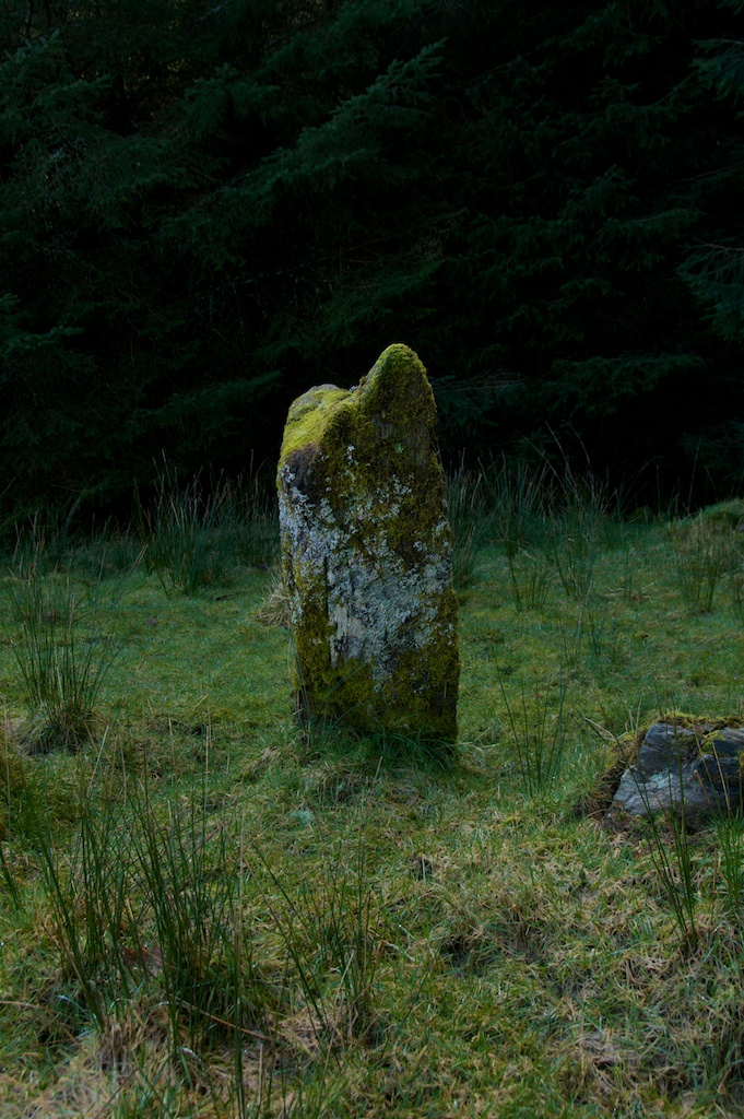
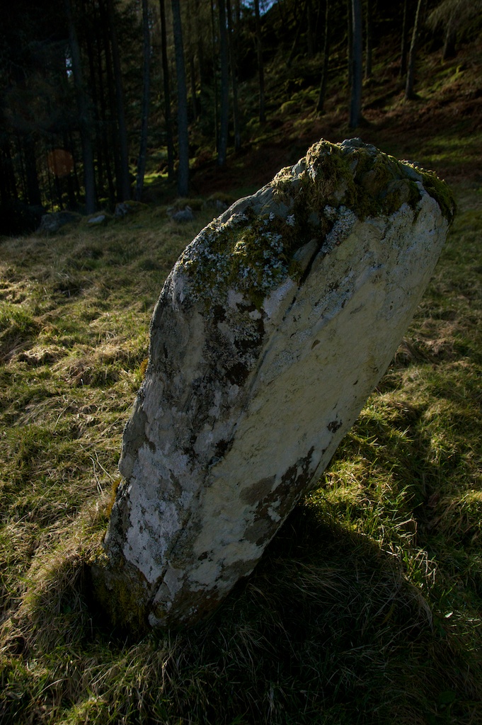
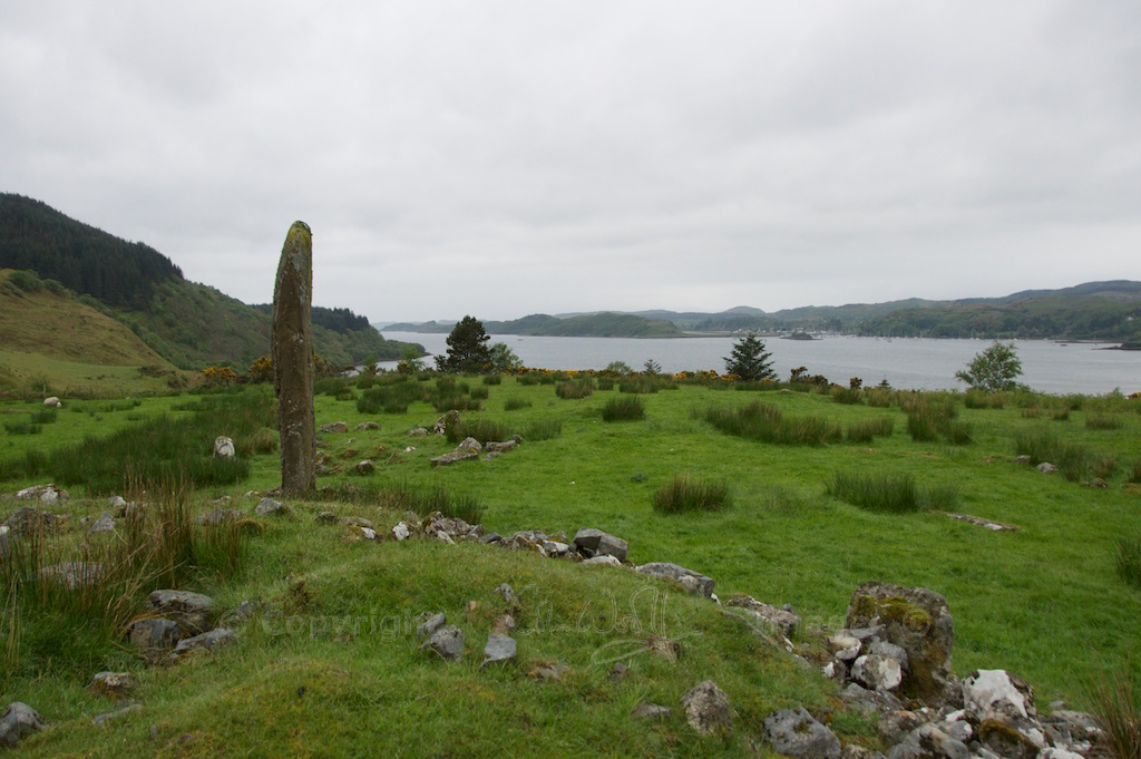
Just to the north-east of Tayvallich, the road snakes around a couple of tight bends before skirting the tip of Loch Coille-Bharr and heading north towards the Crinan Canal. On one of the bends a grassy mound meets your eye, and suddenly you see that there is a stone poking out of it. It is angled like a grave stone, but the overall impression isn’t of a graveyard. If you’re intrigued enough to stop the car and walk up to it, you will realise that there is a second stone in the shadow of the woodland – but the identity of the site is no clearer.
 On consulting the website of the Royal Commission on the Ancient & Historical Monuments of Scotland, I found that the site takes the name of a nearby abandoned village: Kilmory Oib. I’ve never come across ‘Oib’ before, but apparently it stems from a Gaelic word meaning ‘bay’ or ‘inlet’. ‘Kilmory’ denotes a church, dedicated to a saint – perhaps St Maelrubha, like the one at Kilmory Knap.
Kilmory Oib
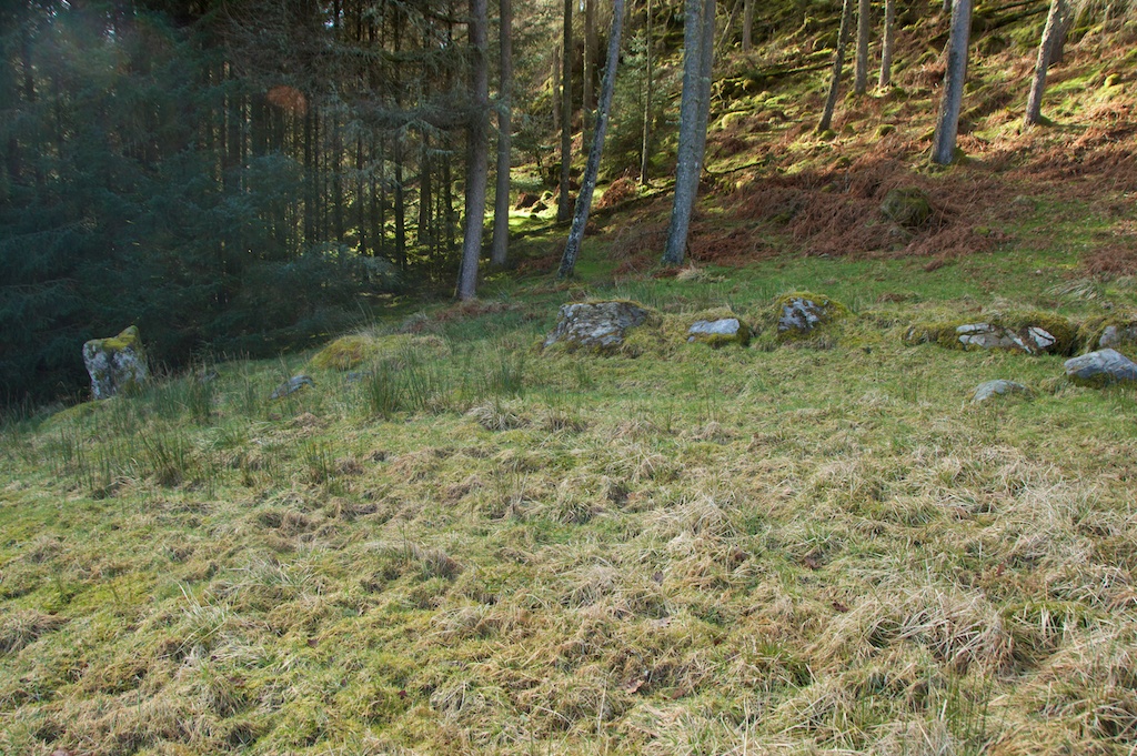
A township of about 17 buildings, including houses and byres, once stood nearby, on the shore of Loch Coille-Bharr. Somewhere in those woodlands are the remains of these buildings, together with a cross-marked stone dating from the 8th or 9th century. It isn’t known exactly when the settlement was abandoned, but it may have been in 1848, when tenants at Kilmory and the neighbouring village of Arichonan were evicted by their landlords. This was the time of the Clearances, when thousands of people across Scotland were turned out of their homes to make way for agriculture. The tenants at Kilmory rioted, and it is recorded that among them were two brothers named MacMillan.
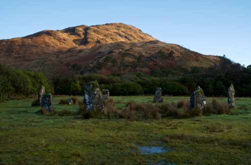
But this doesn’t really solve the riddle of these stones, because they look as if they pre-date the Clearances by at least a thousand years. When the site was first surveyed it was described as a ‘stone circle’, but now it is more warily classed as an ‘enclosure’. The bank to the east is thought to have been artificially raised, to create a level area. But for what?


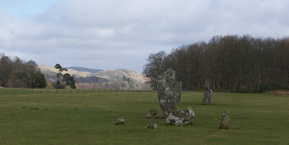
The mound measures about 20 yards across at its widest, narrowing to 12 yards; the standing stones are both roughly four feet high, and are aligned north-east to south-west. As you walk around the site you are aware of a few other stones lying scattered about, partly buried in the turf, and along the western edge of the enclosure is an arc of boulders “at least one of which appears to be a fallen upright.” (RCAHMS)
 In January 1904, when David Christison described Kilmory Oib in the Proceedings of the Society of Antiquaries of Scotland, he noted that there were 13 recumbent stones among bracken and briars, varying from between three and six feet in length. He was convinced that he was looking at a stone circle of an unusual if not unique shape, and he took a rather dim view of what had happened to it:
“Whether the south-east side was originally lined by stones like the north-west side must remain doubtful… it is likely enough that they did exist and have been used up for road metal, as the circle stands temptingly, almost touching the highway.”
Over 100 years later, we don’t know a great deal more. I agree with the RCAHMS that you can’t call two standing stones a circle, nor is there anything to say for sure that they are a deliberate alignment. The RCAHMS also points out, with good reason, that the platform isn’t wide enough to support a circle 20 yards in diameter (because this is the distance between the two standing stones) and there is nothing to suggest the existence of a central cairn. It doesn’t look as if the site has ever been excavated, and no one seems to have made any attempt at dating it.
 When I photographed the south-west stone from a certain angle, it looked like a little old woman emerging from the woodland, carrying a sack over her back; she has a rich ‘hood’ of soft green moss and a silvery apron of lichen. The other stone is leaning drunkenly, and the ground between them is a mass of lumps and bumps, suggesting the possibility of further stones beneath the turf.


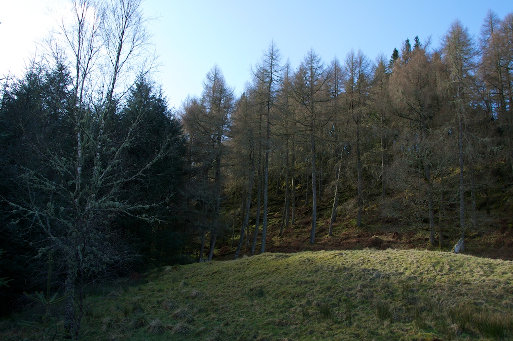
 So many questions… so few answers! It feels like a jigsaw puzzle of which only a handful of random pieces remain. If you open a large-scale map of this area you’ll see it is dotted with cairns, crannogs, cup-marked stones and the small forts known as duns. Just a few miles to the north is Kilmartin, another ancient landscape where you can scarcely walk 50 yards without stumbling over a burial cairn or a stone row. At one time, people would have passed these stones and known them, touched them, and perhaps stopped at them to leave an offering, a blessing, or even a curse. They would have been like old friends. Where has all that wisdom gone?
Sources:
- Royal Commission on the Ancient and Historical Monuments of Scotland
- Proceedings of the Society of Antiquaries of Scotland, January 1904
Photos copyright © Jo Woolf, March 2015
FOOTNOTE, August 2018:
I’ve since visited the abandoned settlements of Kilmory Oib and Arichonan, and written about them here on The Hazel tree.
Nearby sites in Kilmartin Glen
19 Comments
mysearchformagic
What a fascinating place – I love a mystery!
Jo Woolf
Exactly – I am sure you’d love this place! 🙂
Hazel Stark
What a treasure to stumble upon!
Jo Woolf
I know, Hazel, I love finding places like this! 🙂
david
Well done Jo for the thoroughness of your investigations!
Jo Woolf
Thank you very much, David! I do my best! 🙂
Diane Morrow
Standing stones are mentioned in the Old Testament. Interesting. Thank you
Jo Woolf
That’s interesting, Diane. They have certainly played an important role for many thousands of years.
blosslyn
They look similar to ones on Barra, just a few together. Lovely photos and I love the different colours of the moss 🙂
Jo Woolf
Barra sounds a lovely place, Lynne! I love all your photos from there. Plenty of moss and lichen in Knapdale, you can tell how soft and damp the climate is!
tearoomdelights
Wonderful photographs and a most intriguing puzzle. I can clearly see that little old woman you describe so well. The RCAHMS is a mine of information and you make very good use of it.
Jo Woolf
Thank you very much, Lorna! I love finding places like this. If stones could speak, I feel that little old woman is a clear message! The RCAHMS website is excellent because it preserves reports from years ago, as well as more recent ones, so you get a very full picture with different opinions and info on the same site.
Lorna Phillips
My sister has traced our ancestors to this place. She has been there and wants some of her ashes scattered there. I will visit and do that for her soon. It looks lovely and peaceful.
Jo Woolf
What a beautiful place to have in your family history. There can be few more peaceful places to have your sister’s ashes scattered. Thank you for sharing this.
Sue Reed 📚 ✍️ 🌱🏅 (@suereedwrites)
How amazing to have had ancestors living in this wonderful spot, Lorna, a truly special place for your sister’s ashes to be spread.
Lorna Phillips
Our dream will be reality when we visit in August. Anyway to meet you?
Sue Reed 📚 ✍️ 🌱🏅 (@suereedwrites)
A fascinating read. We came across Kilmory Oib a few years ago when staying nearby. I was instantly struck by the sense of history of the place and made lots of notes of my first impressions, wandeing amongst its ruins, thinking about the people who would have lived there. I’m returning now with a research head on, thinking about using this in some fiction I am writing. Great to have found you here at The Hazel Tree.
Lorna Phillips
Hi Sue. I visited Kilmory Oib in September of ‘21 as a tribute to my sister and our ancestors. She found it many years ago while living in Scotland; a place where our family had lived many years ago. She loved that place and so do I. It’s so beautiful and serene. Wishing you luck in your future writings.
Lorna
Jo Woolf
Thank you, Sue. I’m glad you had a chance to explore Kilmory Oib – so much history and atmosphere there. Really exciting that you’re inspired to write some fiction – good luck with your new project.